
기후 조건은 태평양 해분에서 발생하여 기후 변화를 일으키는 엘니뇨와 라니냐 현상 때문에 불규칙하다. 그렇긴 하나 전반적으로 연중 내내 온화하고 시원하며, 밤에는 바람 때문에 매우 춥다.

The climate in Cajicá is comfortable and overcast. Over the course of the year, the temperature typically varies from 44°F to 66°F and is rarely below 37°F or above 70°F.[1]
Climate conditions are irregular due to the El Niño and La Niña phenomena that occur in the Pacific Ocean and cause climate change. However, overall it is mild and cool all year round, and at night it is very cold due to wind.
El clima en Cajicá es confortable y nublado todo el año, la temperatura generalmente varía de 44 ° F a 66 ° F y rara vez es inferior a 37 ° F o superior a 70 ° F. [1]
Las condiciones climáticas son irregulares debido a los fenómenos de El Niño y La Niña que ocurren en el Océano Pacífico y causan el cambio climático. Sin embargo, en general es suave y fresco durante todo el año, y por la noche es muy frío debido al viento.
Clima

기후 Climate


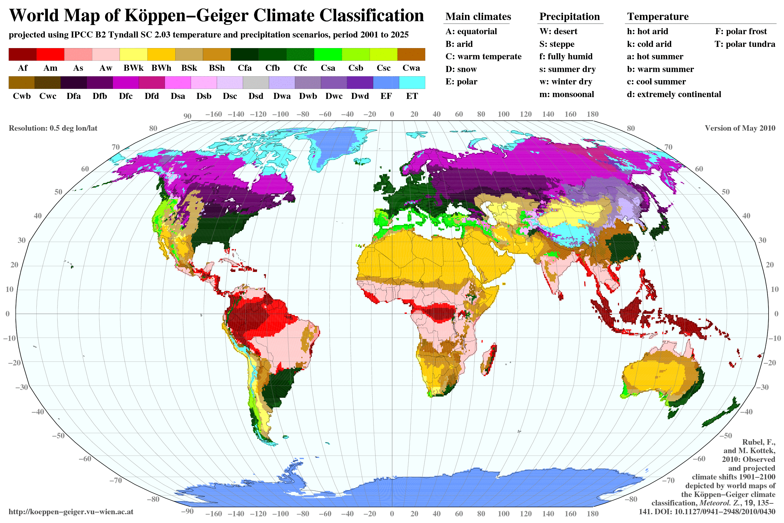
(Cajicá)카히카 서안 해양성 기후 ( 쾨펜의 기후 구분, Cfb))[1] 에 속하며, 연평균 기온은 14℃( 57.2 °F).[2] 연중 건기와 우기가 있다, 가장 건조한 달은 12월, 1월, 2월, 3월이며, 가장 비가 많은 달은 4월, 5월, 9월, 10월, 11월이다. 6월과 7월은 보통 우기이지만, 8월은 바람이 많고 맑다.[3] 여름은 쾌적한, 겨울은 짧은, 선선한 및 비가오는; 그리고 일년 내내 흐린입니다. 일년을 통하여, 온도는 전형적으로 7°C에서 19°C로 변하며, 드물게 3°C이하 또는 21°C이상 입니다.[4]
따뜻한 계절은 12월 20일 부터 3월 28일까지 3.2개월 지속되며, 평균 일일 고온이 19°C 이상입니다. 선선한 계절은 6월 22일 부터 8월 30일까지 2.3개월 지속되며, 평균 일일 온도가 18°C 이하입니다.[4]
Cajicá belongs to the Temperate oceanic climate (Köppen climate classification, Cfb)[1], with an average annual temperature of 57 ° F (14 ° C).[2] There are dry seasons and rainy seasons all year round, the driest months are December, January, February, and March, and the months with the highest rain are April, May, September, October, and November. June and July are usually wet, but August is windy and clear.[3] Summer is pleasant, winter is short, cool and rainy; And it's cloudy all year round. Throughout the year, temperatures typically vary from 7 ° C (44.6 ° F )to 19 ° C(66.2 ° F ), and rarely below 3 ° C(37.4° F ) or 21 ° C(69.8° F ).[4] During the rainy months, the temperature tends to be more stable with variations between 9 and 20 °C (48 and 68 °F). June, July and August are the months that present the largest variations of temperature. Hail is a rare phenomenon on the city[3]
The warm season lasts from December 20th to March 28th for 3.2 months and the average daily high temperature is over 19 ° C. The cool season lasts from June 22 to August 30 for 2.3 months with an average daily temperature below 18 ° C. [4]
온도 Temperature
Temperatura
El clima es cálido y templado en Cajicá. Hay precipitaciones durante todo el año en Cajicá. Hasta el mes más seco aún tiene mucha lluvia,[5] esta clasificada como Clima Oceánico, verano suave (Clasificación climática de Köppen, Cfb)[1], con una temperatura promedio anual de 14 ° C (57 °F), [2] tiene estaciones secas y lluviosas durante todo el año, los meses más secos son diciembre, enero, febrero y marzo, y los meses más lluviosos son abril, mayo, septiembre, octubre y noviembre. Los meses de junio y julio suelen ser húmedos, Agosto es ventoso y claro.[3] El verano es agradable, el invierno es corto, fresco y lluvioso; Y está nublado todo el año. A lo largo del año, las temperaturas varían típicamente de 7 ° C (44.6 ° F) a 19 ° C (66.2 °F), y rara vez por debajo de 3 ° C (37.4 °F) o 21 ° C (69.8 °F). [4]
Durante los meses lluviosos, la temperatura tiende a ser más estable con variaciones entre 9 y 20 ° C (48 y 68 ° F). Junio, julio y agosto son los meses que presentan las mayores variaciones de temperatura. El granizo es un fenómeno raro en la ciudad [3]
La temporada cálida dura del 20 de diciembre al 28 de marzo durante 3,2 meses y la temperatura máxima diaria promedio es de más de 19 ° C. La temporada fría dura del 22 de junio al 30 de agosto durante 2,3 meses con una temperatura diaria promedio inferior a 18 ° C [4 ]
El mes más caluroso del año con un promedio de 14.5 °C es marzo. El mes más frío del año es de 13.6 °C es enero.
El mes más seco es enero, con 29 mm. mientras octubre con 112 mm, es el mes con mayores precipitaciones del año.[5]


Fuente: Google Earth , http://koeppen-geiger.vu-wien.ac.at/shifts.htm
Fuente: Google Earth , http://koeppen-geiger.vu-wien.ac.at/shifts.htm

구름 Cloud
일년을 통하여 구름이 하늘을 가리는 평균 퍼센트가 계절을 통하여 가벼운 변화가 있습니다. 년중 밝은 부분은 6월 6일경에 시작하며, 3.7개월 간 지속되며 9월 27일경에 끝납니다. 연중 가장 밝은 날인 8월 7일에, 하늘은 27%는 밝음, 대부분 밝음 또는 일부 구름이 있음이며, 73%는 구름이 있음 또는 대부분 구름이 있습니다. 일년 중 구름이 있는 때는 9월 27일 쯤이며8.3개월동안 지속되어 6월 6일경에 끝납니다. 연중 가장 흐린 날인 4월 14일에, 하늘은 91%는 흐림 또는 대부분 흐림이며 또한 9%는 밝음,대부분 밝음 또는 대부분 구름이 있습니다.[1]
Throughout the year there is a slight change in the average percentage of clouds covering the sky over the season. The clearer part of the year begins around June 6, and lasts for 3.7 months and ending around September 27. On August 7, the clearest day of the year, the sky is clear, mostly clear, or partly cloudy 27% of the time, and overcast or mostly cloudy 73% of the time.The cloudier part of the year begins around September 27 and lasts for 8.3 months and ends around June 6. On April 14, the cloudiest day of the year, the sky is overcast or mostly cloudy 91% of the time, and clear, mostly clear, or partly cloudy 9% of the time.[1]
Durante todo el año, hay un ligero cambio en el porcentaje promedio de nubes que cubren el cielo durante la temporada. La parte más clara del año comienza alrededor del 6 de junio y dura 3,7 meses y termina alrededor del 27 de septiembre. El 7 de agosto, el día más claro del año, el cielo está despejado, casi siempre despejado o parcialmente nublado el 27% del tiempo, y nublado o mayormente nublado el 73% del tiempo. La parte más nublada del año comienza alrededor del 27 de septiembre y dura 8,3 meses y termina alrededor del 6 de junio. El 14 de abril, el día más nublado del año, el cielo está nublado o muy nublado El 91% del tiempo y el 9% del tiempo despejado, en su mayoría despejado, o parcialmente nublado.[1]
1.https://weatherspark.com/y/23322/Average-Weather-in-Cajic%C3%A1-Colombia-Year-Round
Nubosidad

강수량 Precipitation
(Cajicá)카히카에서 비오는 날 기회는 일년을 통하여 많이 변합니다.[1]
강우량
(Cajicá)카히카은 극단적 매달 강수량의 변화가 있습니다.
(Cajicá)카히카에서 비가 일년을 통하여 옵니다. [1]
Rainy days in Cajicá vary greatly throughout the year.[1]
Rainfall
Cajicá experiences extreme seasonal variation in monthly rainfall. Rainfall throughout the year in Cajicá.[1]

Los días lluviosos en Cajicá varían mucho a lo largo del año.[1]Hay alrededor de 830 mm de precipitaciones.[2]
Lluvias
Cajicá tiene una variación extrema de lluvias mensuales por estación. Llueve durante el año en Cajicá.[1]
Precipitaciones


해 Sun
(Cajicá)카히카의 하루의 길이는 일년동안 대체로 변화하지 않으며, 전체를 통하여 12시간에서 24분내로 유지합니다. 2018년에, 가장 짧은 날은 12월 21일에 일광이 11시간 50분이며, 가장 긴 날은 6월 21일에, 일광이 12시간 25분입니다.[1]
해가 가장 빨리 뜰때는 10월 25일 오전 5:41이며, 해가 가장 늦게 뜰때는 2월 3일의 31분늦은 오전 6:12입니다. 해가 가장 일찍 질때는 11월 9일 오후 5:37이며, 가장 늦게 질때는 7월 17일의 36분늦은 오후 6:13입니다[1]
일광 절약 시간은 2018년 동안 (Cajicá)카히카에서 사용되지 않습니다[1]
The length of the day in Cajicá does not change substantially throughout the year, it only varies 24 minutes of the 12 hours throughout the year. In 2018, the shortest day is December 21, with 11 hours, 50 minutes of daylight; with 12 hours, 25 minutes of daylight.[1]
Earliest sunrise: 5:41 AM on October 25
Latest sunrise: 31 minutes later at 6:12 AM on February 3
Earliest sunset: 5:37 PM on November 9
Latest sunset: 36 minutes later at 6:13 PM on July 17[1]
Daylight saving time (DST) is not observed in Cajicá during 2018.[1]
La duración del día en Cajicá no varía considerablemente durante el año, solamente varía 24 minutos de las 12 horas en todo el año. En 2018, el día más corto es el 21 de diciembre, con 11 horas y 50 minutos de luz natural; el día más largo es el 21 de junio, con 12 horas y 25 minutos de luz natural.
Salida del sol más temprana: 5:41 el 25 de octubre
Salida del sol más tardía: 6:12 el 3 de febrero
Puesta del sol más temprana: 17:37 el 9 de noviembre
Puesta del sol más tardía: 18:13 el 17 de julio.
No se usa el horario de verano (HDV) en Cajicá
1.https://weatherspark.com/y/23322/Average-Weather-in-Cajic%C3%A1-Colombia-Year-Round
Sol


인지된 습도 레벨은 습도 안정도를 시간의 퍼센트로 측정한 것이 후덥지근한, 굉장히 더운 또는 구질구질한 상태는 일년을 통하여 크게 변하지 않으며, 거의 일년 내내 0%입니다.[1]
The perceived humidity level, as measured by the percentage of time in which the humidity comfort level is muggy, oppressive, or miserable, does not vary significantly over the course of the year, remaining a virtually constant 0% throughout.[1]
Humedad
El nivel de humedad percibido en Cajicá, medido por el porcentaje de tiempo en el cual el nivel de comodidad de humedad es bochornoso, opresivo o insoportable, no varía considerablemente durante el año, y permanece prácticamente constante en 0 %.[1]
1.https://weatherspark.com/y/23322/Average-Weather-in-Cajic%C3%A1-Colombia-Year-Round
습도 Humidity

평균 시간당 풍속은 일년을 통하여 >약간의 변화가 있습니다.
일년 중 더 바람이 부는때는 5월 31일에서 9월 20일까지 3.7개월 동안 계속되며, 평균 풍속은 시속 5.5킬로미터이상입니다. 일년 중 가장 바람이 많이 부는때는 7월 31일이며, 평균 풍속은 시속 7.3킬로미터입니다. 일년 중 바람이 적게 부는때는 9월 20일에서 5월 31일까지, 8.4개월 동안 계속됩니다. 일년 중 가장 바람이 적게 부는때는 11월 6일이며, 평균 풍속은 시속 3.8킬로미터입니다.[1]
The average hourly wind speed in Cajicá experiences mild seasonal variation over the course of the year. The windier part of the year lasts for 3.7 months, from May 31 to September 20, with average wind speeds of more than 5.5 km / h(3.4 miles per hour). The windiest day of the year is July 31, with average wind speeds of more than 7.3 kilometers per hour(3.4 miles per hour).The calmer time of year lasts for 8.4 months from September 20 to May 31. The calmest day of the year is November 6th with an average hourly wind speed of 3.8 kilometers per hour(2.3 miles per hour).[1]
Viento
La velocidad promedio del viento por hora en Cajicá tiene variaciones estacionales leves en el transcurso del año. La parte más ventosa del año dura 3,7 meses, del 31 de mayo al 20 de septiembre, con velocidades promedio del viento de más de 5,5 kilómetros por hora. El día más ventoso del año en el 31 de julio, con una velocidad promedio del viento de 7,3 kilómetros por hora. El tiempo más calmado del año dura 8,4 meses, del 20 de septiembre al 31 de mayo. El día más calmado del año es el 6 de noviembre, con una velocidad promedio del viento de 3,8 kilómetros por hora.[1]
1.https://weatherspark.com/y/23322/Average-Weather-in-Cajic%C3%A1-Colombia-Year-Round
바람 Wind


평균 일당 입사 단파 태양력은 일년을 통하여 약간의 계절적 변화가 있습니다. 일년 중 더 밝은 기간은 7월 28일부터 9월 22일까지 1.8개월 동안 지속되며, 평방 미터당 평균 일당 입사 단파 태양력은 5.8kWh이상 입니다. 일년 중 가장 밝은 날은 8월 25일이며, 평균 6.0kWh입니다. 일년 중 더 어두운 기간은 10월 20일부터 12월 14일까지 1.8개월 동안 지속되며, 평방 미터당 평균 일당 입사 단파 태양력은 5.0kWh이하 입니다. 일년 중 가장 어두운 날은 11월 11일이며, 평균 4.8kWh입니다.[1]
The average daily incident shortwave solar energy experiences some seasonal variation over the course of the year. The brighter period of the year lasts for 1.8 months, from July 28 to September 22, with an average daily incident shortwave energy per square meter above 5.8 kWh. The brightest day of the year is August 25, with an average of 6.0 kWh. The darker period of the year lasts for 1.8 months, from October 20 to December 14, with an average daily incident shortwave energy per square meter below 5.0 kWh. The darkest day of the year is November 11, with an average of 4.8 kWh.[1]
Energía Solar
La energía solar de onda corta incidente promedio diaria tiene variaciones estacionales leves durante el año. El período más resplandeciente del año dura 1,8 meses, del 28 de julio al 22 de septiembre, con una energía de onda corta incidente diaria promedio por metro cuadrado superior a 5,8 kWh. El día más resplandeciente del año es el 25 de agosto, con un promedio de 6,0 kWh. El periodo más obscuro del año dura 1,8 meses, del 20 de octubre al 14 de diciembre, con una energía de onda corta incidente diaria promedio por metro cuadrado de menos de 5,0 kWh. El día más obscuro del año es el 11 de noviembre, con un promedio de 4,8 kWh.[1]
1.https://weatherspark.com/y/23322/Average-Weather-in-Cajic%C3%A1-Colombia-Year-Round
태양력 Solar Energy

본 보고서는 기후 통계 분석 시간적 기후 보고서 및 1980년 1월 1일부터 2016년 12월 31일까지 모델 재구성에 근거한, Cajicá의 전형적 기후를 보여줍니다.
-
본 네트워크에서 Cajicá의 기록적 기온 및 이슬점을 의존할 수 있는 기상 관측소는 엘도라도 국제공항(El Dorado International Airport)의 단지 한 곳만 있습니다.
-
국제 기준 대기
-
MERRA-2 현대 시대 회고 분석(MERRA-2 Modern-Era Retrospective Analysis)NASA
-
(Jean Meeus)의 태양, 달 및 행성의 천문학 테이블(Astronomical Tables of the Sun, Moon and Planets)를
-
유엔 식량 농업기구에서 (FAO) 글로벌 토지커버 공용 데이터베이스(Global Land Cover SHARE database)
-
고도 데이터는 나사의 제트 추진 연구소에서 출판된 셔틀 레이더 지형 미션(Shuttle Radar Topography Mission (SRTM))에서 유래됩니다.
-
GeoNames Geographical Database (GeoNames 지리 데이터베이스)
-
AskGeo.com
-
지도들은 © Esri, National Geographic의 데이터와 함께, Esri, DeLorme, NAVTEQ, UNEP-WCMC, USGS, NASA, ESA, METI, NRCAN, GEBCO, NOAA, 및 iPC.
Disclaimer
본 사이트에 있는 정보는 어떤 목적으로도 정확도 및 적절성에 관한 어떤 보증없이 제공됩니다. 기상 데이터는 오차, 급변 및 다른 결함들이 발생하기 쉽습니다. 본 사이트에 제공된 내용을 근거로 결정을 내린 것에 대하여 본사는 어떤 책임도 없습니다.[1]
This report illustrates the typical weather in Cajicá, based on a statistical analysis of historical hourly weather reports and model reconstructions from January 1, 1980 to December 31, 2016.
-
There is only a single weather station, El Dorado International Airport, in our network suitable to be used as a proxy for the historical temperature and dew point records of Cajicá.
-
the International Standard Atmosphere ,
-
MERRA-2 satellite-Modern-Era Retrospective Analysis
-
Astronomical Tables of the Sun, Moon and Planets , by Jean Meeus.
-
Global Land Cover SHARE database , by the Food and Agriculture Organization of the United Nations.
-
Shuttle Radar Topography Mission (SRTM) , by NASA's Jet Propulsion Laboratory.
-
GeoNames Geographical Database .
-
AskGeo.com .
-
Maps are © Esri, with data from National Geographic, Esri, DeLorme, NAVTEQ, UNEP-WCMC, USGS, NASA, ESA, METI, NRCAN, GEBCO, NOAA, and iPC.
Disclaimer
The information on this site is provided as is, without any assurances as to its accuracy or suitability for any purpose. Weather data is prone to errors, outages, and other defects. We assume no responsibility for any decisions made on the basis of the content presented on this site.[1]
Fuentes Informativas
Este informe ilustra el clima típico en Cajicá, basado en un análisis estadístico de informes climatológicos históricos por hora y reconstrucciones de modelos del 1 de enero de 1980 al 31 de diciembre de 2016.[1]
-
Estación meteorológica, Aeropuerto El Dorado, en nuestra red adecuada para usarla como representante de los registros históricos de temperatura y punto de rocío de Cajicá.
-
International Standard Atmosphere
-
Satélite MERRA-2.Modern-Era Retrospective Analysis de NASA.
-
Astronomical Tables of the Sun, Moon and Planets , de Jean Meeus.
-
Global Land Cover SHARE database , Organización de las Naciones Unidas para la Alimentación y Agricultura.
-
Shuttle Radar Topography Mission (SRTM) , Jet Propulsion Laboratory de la NASA.
-
GeoNames Geographical Database .
-
AskGeo.com.
-
Los mapas tienen © de Esri, con datos de National Geographic, Esri, DeLorme, AVTEQ, UNEP-WCMC, USGS, NASA, ESA, METI, NRCAN, GEBCO, NOAA y iPC
Disclaimer
La información de este sitio se proporciona tal cual, sin garantías sobre su veracidad o idoneidad para un fin en particular. Los datos climatológicos son propensos a errores, discrepancias y otros defectos. No asumimos responsabilidad alguna por decisiones tomadas en base al contenido de este sitio.[1]
FUENTES PENDIENTES POR CONSULTAR
-
1.https://weatherspark.com/y/23322/Average-Weather-in-Cajic%C3%A1-Colombia-Year-Round
-
ftp://ftp.ani.gov.co/Iniciativas%20Privadas/IP%20ACCESOS%20NORTE%20FASE%201/09%20An%C3%A1lisis%20Ambiental/9.2-HATOGRANDE/9.2.2-CAPITULOS/CAP-4-CARACTERIZACION..pdf
-
MAVDT. Reglamento Técnico del Sector de Agua Potable y Saneamiento Basico
-
RAS – 2000. Sección II Título B, Sistemas de Acueducto. Bogotá D.C. 2000. Colombia
-
MAVDT. Reglamento Técnico del Sector de Agua Potable y Saneamiento Basico RAS – 2000. Definición del nivel de complejidad y evaluación de la población, la dotación y la demanda de agua.
-
Guía RAS – 001. Bogotá D.C. 2003. Colombia
-
MAVDT. Metodología para el análisis de tensiones, interacciones y balances en dinámicas y desarrollos poblacionales, ambientales, sociales y económicos.
-
https://www.accuweather.com/ru/co/cajica/108242/weather-forecast/108242?lang=ru
데이터 소스 Data Sources
